Cap-d'Ail
Commune in Provence-Alpes-Côte d'Azur, France
You can help expand this article with text translated from the corresponding article in French. (December 2008) Click [show] for important translation instructions.
- View a machine-translated version of the French article.
- Machine translation, like DeepL or Google Translate, is a useful starting point for translations, but translators must revise errors as necessary and confirm that the translation is accurate, rather than simply copy-pasting machine-translated text into the English Wikipedia.
- Do not translate text that appears unreliable or low-quality. If possible, verify the text with references provided in the foreign-language article.
- You must provide copyright attribution in the edit summary accompanying your translation by providing an interlanguage link to the source of your translation. A model attribution edit summary is
Content in this edit is translated from the existing French Wikipedia article at [[:fr:Cap-d'Ail]]; see its history for attribution. - You may also add the template
{{Translated|fr|Cap-d'Ail}}to the talk page. - For more guidance, see Wikipedia:Translation.
Commune in Provence-Alpes-Côte d'Azur, France
Cap-d'Ail Caup d'Alh (Occitan) | ||
|---|---|---|
Commune | ||
 A view on the Mediterranean coastline in Cap-d'Ail | ||
 Coat of arms | ||
Location of Cap-d'Ail  | ||
(2020–2026) Xavier Beck[1] | | |
| Area 1 | 2.04 km2 (0.79 sq mi) | |
| Population (2021)[2] | 4,508 | |
| • Density | 2,200/km2 (5,700/sq mi) | |
| Time zone | UTC+01:00 (CET) | |
| • Summer (DST) | UTC+02:00 (CEST) | |
| INSEE/Postal code | 06032 /06320 | |
| Elevation | 0–540 m (0–1,772 ft) | |
| 1 French Land Register data, which excludes lakes, ponds, glaciers > 1 km2 (0.386 sq mi or 247 acres) and river estuaries. | ||
Cap-d'Ail (French pronunciation: [kap daj]; Occitan: Caup d'Alh; Italian: Capodaglio or Capo d'Aglio) is a seaside commune in the Alpes-Maritimes department in the Provence-Alpes-Côte d'Azur region in Southeastern France.
Geography
Cap-d'Ail borders the areas of La Colle, Les Révoires and Fontvieille in the Principality of Monaco.
Contemporary Cap-d'Ail is a modern seaside resort with a lively shopping district on the Basse Corniche and quiet, fashionable residential areas. Many people who work in Monaco live there. Plage Mala is prized by many day trippers from Monaco and Nice.
Cap-d'Ail is served by a 1881 station on the Marseille–Ventimiglia railway, the last before the Monégasque border.
-
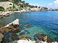 Coastline in Cap-d'Ail
 -
 Cap-d'Ail from the sea
 -
 Château des Terrasses
 -
 Sea cliffs
 -
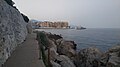 Littoral path between Cap d'Ail and Monaco


History
On 13 September 1982, Princess Grace de Monaco was killed in a car accident.[3]
Demographics
| Year | Pop. | ±% p.a. |
|---|---|---|
| 1968 | 4,200 | — |
| 1975 | 4,282 | +0.28% |
| 1982 | 4,402 | +0.40% |
| 1990 | 4,859 | +1.24% |
| 1999 | 4,532 | −0.77% |
| 2009 | 5,024 | +1.04% |
| 2014 | 4,711 | −1.28% |
| 2020 | 4,517 | −0.70% |
| Source: INSEE[4] | ||
See also
References
- ^ "Répertoire national des élus: les maires". data.gouv.fr, Plateforme ouverte des données publiques françaises (in French). 2 December 2020.
- ^ "Populations légales 2021" (in French). The National Institute of Statistics and Economic Studies. 28 December 2023.
- ^ Haberman, Clyde (15 September 1982). "PRINCESS GRACE IS DEAD AFTER RIVIERA CAR CRASH". The New York Times. ISSN 0362-4331. Retrieved 13 September 2022.
- ^ Population en historique depuis 1968, INSEE
Wikimedia Commons has media related to Cap-d'Ail.
- v
- t
- e

- Aiglun
- Amirat
- Andon
- Antibes
- Ascros
- Aspremont
- Auribeau-sur-Siagne
- Auvare
- Bairols
- Le Bar-sur-Loup
- Beaulieu-sur-Mer
- Beausoleil
- Belvédère
- Bendejun
- Berre-les-Alpes
- Beuil
- Bézaudun-les-Alpes
- Biot
- Blausasc
- La Bollène-Vésubie
- Bonson
- Bouyon
- Breil-sur-Roya
- Briançonnet
- La Brigue
- Le Broc
- Cabris
- Cagnes-sur-Mer
- Caille
- Cannes
- Le Cannet
- Cantaron
- Cap-d'Ail
- Carros
- Castagniers
- Castellar
- Castillon
- Caussols
- Châteauneuf-d'Entraunes
- Châteauneuf-Grasse
- Châteauneuf-Villevieille
- Cipières
- Clans
- Coaraze
- La Colle-sur-Loup
- Collongues
- Colomars
- Conségudes
- Contes
- Courmes
- Coursegoules
- La Croix-sur-Roudoule
- Cuébris
- Daluis
- Drap
- Duranus
- Entraunes
- L'Escarène
- Escragnolles
- Èze
- Falicon
- Les Ferres
- Fontan
- Gars
- Gattières
- La Gaude
- Gilette
- Gorbio
- Gourdon
- Grassesubpr
- Gréolières
- Guillaumes
- Ilonse
- Isola
- Lantosque
- Levens
- Lieuche
- Lucéram
- Malaussène
- Mandelieu-la-Napoule
- Marie
- Le Mas
- Massoins
- Menton
- Mouans-Sartoux
- Mougins
- Moulinet
- Les Mujouls
- Nicepref
- Opio
- Pégomas
- Peille
- Peillon
- La Penne
- Péone
- Peymeinade
- Pierlas
- Pierrefeu
- Puget-Rostang
- Puget-Théniers
- Revest-les-Roches
- Rigaud
- Rimplas
- Roquebillière
- Roquebrune-Cap-Martin
- La Roque-en-Provence
- Roquefort-les-Pins
- Roquestéron
- La Roquette-sur-Siagne
- La Roquette-sur-Var
- Roubion
- Roure
- Le Rouret
- Saint-André-de-la-Roche
- Saint-Antonin
- Saint-Auban
- Saint-Blaise
- Saint-Cézaire-sur-Siagne
- Saint-Dalmas-le-Selvage
- Sainte-Agnès
- Saint-Étienne-de-Tinée
- Saint-Jean-Cap-Ferrat
- Saint-Jeannet
- Saint-Laurent-du-Var
- Saint-Léger
- Saint-Martin-d'Entraunes
- Saint-Martin-du-Var
- Saint-Martin-Vésubie
- Saint-Paul-de-Vence
- Saint-Sauveur-sur-Tinée
- Saint-Vallier-de-Thiey
- Sallagriffon
- Saorge
- Sauze
- Séranon
- Sigale
- Sospel
- Spéracèdes
- Tende
- Théoule-sur-Mer
- Thiéry
- Le Tignet
- Toudon
- Touët-de-l'Escarène
- Touët-sur-Var
- La Tour
- Tourette-du-Château
- Tournefort
- Tourrette-Levens
- Tourrettes-sur-Loup
- La Trinité
- La Turbie
- Utelle
- Valbonne
- Valdeblore
- Valderoure
- Vallauris
- Venanson
- Vence
- Villars-sur-Var
- Villefranche-sur-Mer
- Villeneuve-d'Entraunes
- Villeneuve-Loubet
- pref: prefecture
- subpr: subprefecture
Authority control databases | |
|---|---|
| International |
|
| National |
|
 | This Alpes-Maritimes geographical article is a stub. You can help Wikipedia by expanding it. |
- v
- t
- e


