Gaanderen
Village in Gelderland, Netherlands

Flag

Coat of arms
51°55′41″N 6°20′41″E / 51.92806°N 6.34472°E / 51.92806; 6.34472
(2021)[1]
7011[1]
Gaanderen is a village in the Dutch province of Gelderland. It is located in the municipality of Doetinchem. The number of inhabitants is around 5,575 (2020).[3]
It was first mentioned around 1200 as de Gernere, and means "tapering land on a sandy ridge".[4]
Gaanderen was home to 482 people in 1840.[5] The St Martinus Church dates from 1913 and is a replacement of a 1854 church. The tower of the old church remained.[5]
Transportation
- Railway Station: Gaanderen
- Rijksweg Doetinchem - Terborg
Gallery
-
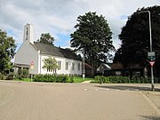 Hoofdstraat 62, church
 -
 Rekhemseweg 175
 -
 Kerkstraat 45
 -
 Bloemenweg 1
 -
 Station Gaanderen


References
- ^ a b c "Kerncijfers wijken en buurten 2021". Central Bureau of Statistics. Retrieved 13 April 2022.
- ^ "Postcodetool for 7011AA". Actueel Hoogtebestand Nederland (in Dutch). Het Waterschapshuis. Retrieved 13 April 2022.
- ^ Kerncijfers Wijken en buurten_2020-1
- ^ "Gaanderen - (geografische naam)". Etymologiebank (in Dutch). Retrieved 13 April 2022.
- ^ a b "Gaanderen". Plaatsengids (in Dutch). Retrieved 13 April 2022.
Wikimedia Commons has media related to Gaanderen.
- v
- t
- e
Populated places in the municipality of Doetinchem
- Doetinchem
- Wehl
- Gaanderen
- Nieuw-Wehl


