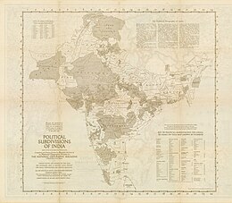
Patiala State
Indian royal state that existed from 1763 to 1947
State of Patiala | |||||||||||||||||||
|---|---|---|---|---|---|---|---|---|---|---|---|---|---|---|---|---|---|---|---|
| 1763–1947 | |||||||||||||||||||
 Flag  Coat of arms | |||||||||||||||||||
| Capital | Patiala | ||||||||||||||||||
| Common languages | Punjabi (official) | ||||||||||||||||||
| Religion | Sikh | ||||||||||||||||||
| Government | Absolute monarchy | ||||||||||||||||||
| Maharaja | |||||||||||||||||||
• 1707 - 1765 | Ala Singh | ||||||||||||||||||
• 1938 - 1947 | Yadavindra Singh | ||||||||||||||||||
| History | |||||||||||||||||||
• Established | 1763 | ||||||||||||||||||
• Disestablished | 1947 | ||||||||||||||||||
| Area | |||||||||||||||||||
• Total | 15,389 km2 (5,942 sq mi) | ||||||||||||||||||
| Population | |||||||||||||||||||
• 1881[1] | 1,467,433 | ||||||||||||||||||
• 1891[1] | 1,583,521 | ||||||||||||||||||
• 1901[1] | 1,596,692 | ||||||||||||||||||
| Currency | Rupee and Paisa | ||||||||||||||||||
| |||||||||||||||||||
| Today part of | India Pakistan | ||||||||||||||||||
| |||||||||||||||||||
Patiala State was a self-governing princely state in British India, and one of the Phulkian States, that acceded to the Union of India upon Indian independence and partition in 1947. The state was founded by Sidhu Jat Sikhs. Patiala State was the largest and most important princely state in the Punjab Province.[2] The state's ruler, the Maharaja of Patiala, was entitled to a 17-gun salute and held precedence over all other princes in the Punjab Province during the British Raj.[3]
Etymology
The state's name came from the name of its principal city and capital, Patiala, which itself comes from the roots patti and ala. The word patti means "strip of land" in Punjabi, and 'ala' comes from the name of the founder of the city and Patiala state, Ala Singh, thus meaning ‘the land of Ala Singh’.[4]
History
Part of a series on the |
|---|
| History of India |
 |
| Timeline |
| Prehistoric
|
| Ancient
|
|
|
|
| Early modern
|
| Modern
|
| Related articles
|
|
Patiala State was founded by Ala Singh, the first Maharaja of Patiala in 1763, when, after the Battle of Sirhind, the Sikh Confederation partitioned the Sirhind area and gave the territory to Ala Singh.[5] At its height, during the British Raj, the state's territory also extended to areas in what is now Himachal Pradesh, including Shimla and Chail.[6] In 1947, Yadavindra Singh, the last Maharaja of Patiala, agreed to the accession of Patiala State into the independent Dominion of India.[7]
Rulers and titles
Maharajas
- 29 March 1761 – 22 August 1765: Ala Singh (b. 1691 – d. 1765)
- 22 August 1765 – 1767: Amar Singh (b. 1748 – d. 1781)
Raja-e Rajgan
- 1767 – 5 February 1781: Amar Singh (s.a.)
- February 1781 – 1810: Sahib Singh (b. 1774 – d. 1813)
Maharaja-e Rajgan
- 1810 – 26 March 1813: Sahib Singh (s. a.)
- 26 March 1813 – 23 December 1845: Karam Singh (b. 1797 – d. 1845)
- 26 March 1813 – 1823: Maharani Aus Kaur (f) – Regent (b. 1772 – d. af.1823)
- 23 Dec 1845 – 13 November 1862: Narendra Singh (b. 1823 – d. 1862) (from 25 June 1861 Sir Narendra Singh)
- 13 November 1862 – 14 April 1876: Mahendra Singh (b. 1852 – d. 1876) (from 28 May 1870 Sir Mahendra Singh)
- 13 Nov 1862 – 26 February 1870: Jagdish Singh (Regent, chairman of regency council)
- 14 Apr 1876 – 9 November 1900: Rajinder Singh (b. 1872 – d. 1900) (from 21 May 1898 Sir Rajendra Singh)
- 14 April 1876 – October 1890: Sir Deva Singh (Regent) (b. 1834 – d. 1890) (chairman of regency council)
- 9 November 1900 – 23 March 1938: Bhupinder Singh (b. 1891 – d. 1938) (from 12 December 1911 Sir Bhupindra Singh)
- 9 November 1900 – 3 November 1910: Sardar Gurmukh Singh – (Regent, chairman of regency council)
- 23 Mar 1938 – 15 August 1947: Yadavindra Singh (b. 1913 – d. 1974) (from 1 January 1942 Sir Yadavindra Singh)
Demographics
| Religious group | 1901[8] | 1911[9][10] | 1921[11] | 1931[12] | 1941[13] | |||||
|---|---|---|---|---|---|---|---|---|---|---|
| Pop. | % | Pop. | % | Pop. | % | Pop. | % | Pop. | % | |
Hinduism  [a] [a] | 880,490 | 55.14% | 563,940 | 40.06% | 642,055 | 42.81% | 623,597 | 38.36% | 597,488 | 30.86% |
Islam  | 357,334 | 22.38% | 307,384 | 21.84% | 330,341 | 22.03% | 363,920 | 22.39% | 436,539 | 22.55% |
Sikhism  | 355,649 | 22.27% | 532,292 | 37.81% | 522,675 | 34.85% | 632,972 | 38.94% | 896,021 | 46.28% |
Jainism  | 2,877 | 0.18% | 3,282 | 0.23% | 3,249 | 0.22% | 3,578 | 0.22% | 3,101 | 0.16% |
Christianity  | 316 | 0.02% | 739 | 0.05% | 1,395 | 0.09% | 1,449 | 0.09% | 1,592 | 0.08% |
Zoroastrianism  | 26 | 0% | 22 | 0% | 21 | 0% | 2 | 0% | 21 | 0% |
Buddhism  | 0 | 0% | 0 | 0% | 3 | 0% | 2 | 0% | 3 | 0% |
Judaism  | 0 | 0% | 0 | 0% | 0 | 0% | 0 | 0% | 12 | 0% |
| Others | 0 | 0% | 0 | 0% | 0 | 0% | 0 | 0% | 1,482 | 0.08% |
| Total population | 1,596,692 | 100% | 1,407,659 | 100% | 1,499,739 | 100% | 1,625,520 | 100% | 1,936,259 | 100% |
| Note: British Punjab province era district borders are not an exact match in the present-day due to various bifurcations to district borders — which since created new districts — throughout the historic Punjab Province region during the post-independence era that have taken into account population increases. | ||||||||||
Gallery
-
 Sardar Jassa Singh Ramgarhia on left and Amar Singh of Patiala on right, late 18th century
 -
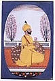 Miniature painting of Raja Amar Singh of Patiala, ca.1830
 -
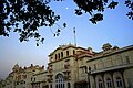 Moti Bagh Palace, Patiala.
 -
 The main gate of the Qila Mubarak
 -
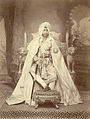
 Maharaja Bhupinder Singh of Patiala
 -
 Maharaja Mahendra Singh of Patiala
 -
 Maharaja Rajinder Singh of Patiala
 -
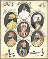 A panel of seven portraits of rulers of Patiala State
 -
 Detail of an informal visit at Moti Bagh Palace from an album of photographs compiled by the wife of Dr. H.R. Hunter during his time as Dental Surgeon at Moti Bagh Palace during the reign of Maharajah Bhupinder Singh, circa 1922–23


See also
- Maharaja of Patiala
- Patiala State Monorail Trainways
- Political integration of India
- Phulkian sardars
- Nabha State
- Jind State
- Faridkot State
- Malaudh
- Bhadaur
- Kaithal
- Cis-Sutlej states
- Nanu Singh Saini
- 85 (Patiala) Field Battery
Notes
- ^ 1931-1941: Including Ad-Dharmis
References
- ^ a b c Imperial gazetteer of India. Vol. XX Pardi to Pusad. 1908. pp. 40, 42.
- ^ Bond, J. W.; Wright, Arnold (2006). Indian States: A Biographical, Historical, and Administrative Survey. New Delhi: Asian Educational Services. pp. 232–242. ISBN 978-81-206-1965-4. Archived from the original on 20 June 2024. Retrieved 13 June 2024.
- ^ Punjab District and State Gazetteers: Part A]. Punjab Government Press: Punjab Government Press. 1900. p. 51. Archived from the original on 20 June 2024. Retrieved 13 June 2024.
- ^ Kaur, Roopam Jasmeet; Idris, Mohammad (2011). "The Development of Education in Patiala District (1948-2001): A Gendered Analysis". Proceedings of the Indian History Congress. 72: 1460–1470. JSTOR 44145757.
- ^ Punjab District and State Gazetteers: Part A]. Part 1. Punjab Government Press. 1900. pp. 46–52. Archived from the original on 20 June 2024. Retrieved 13 June 2024.
- ^ Singh, Khushwant (15 February 2017). Captain Amarinder Singh: The People's Maharaja: An Authorized Biography. Hay House, Inc. ISBN 978-93-85827-44-0. Archived from the original on 20 June 2024. Retrieved 20 June 2024.
- ^ Panjab Past and Present. Patiala: Department of Punjab Historical Studies, Punjabi University. 2000. pp. 94–97. Archived from the original on 20 June 2024. Retrieved 20 June 2024.
- ^ "Census of India 1901. [Vol. 17A]. Imperial tables, I-VIII, X-XV, XVII and XVIII for the Punjab, with the native states under the political control of the Punjab Government, and for the North-west Frontier Province". 1901. p. 34. JSTOR saoa.crl.25363739. Archived from the original on 28 January 2024. Retrieved 30 March 2024.
- ^ "Census of India 1911. Vol. 14, Punjab. Pt. 2, Tables". 1911. p. 27. JSTOR saoa.crl.25393788. Archived from the original on 9 January 2024. Retrieved 30 March 2024.
- ^ Kaul, Harikishan (1911). "Census Of India 1911 Punjab Vol XIV Part II". p. 27. Retrieved 30 March 2024.
- ^ "Census of India 1921. Vol. 15, Punjab and Delhi. Pt. 2, Tables". 1921. p. 29. JSTOR saoa.crl.25430165. Archived from the original on 26 March 2023. Retrieved 30 March 2024.
- ^ "Census of India 1931. Vol. 17, Punjab. Pt. 2, Tables". 1931. p. 277. JSTOR saoa.crl.25793242. Archived from the original on 31 October 2023. Retrieved 30 March 2024.
- ^ India Census Commissioner (1941). "Census of India, 1941. Vol. 6, Punjab". p. 42. JSTOR saoa.crl.28215541. Archived from the original on 2 October 2022. Retrieved 30 March 2024.
Further reading
- Chavan, Akshay (15 February 2019), "Hitler's Gift to The Maharaja of Patiala", Live History India
- Dhavan, Purnima (2011). When Sparrows Became Hawks: The Making of the Sikh Warrior Tradition, 1699-1799. Oxford University Press (US). ISBN 978-0199756551.
- Priscoli, Jerome Delli; Wolf, Aaron T. (2010). Managing and Transforming Water Conflicts. Cambridge University Press. ISBN 978-0521632164.
External links
- Imperial Gazetteer2 of India, Volume 20, page 40 -- Imperial Gazetteer of India -- Digital South Asia Library
Authority control databases | |
|---|---|
| International |
|
| National |
|
31°07′N 77°38′E / 31.117°N 77.633°E / 31.117; 77.633


